Disclaimer:
All products, displays, and information hosted on this site should be considered experimental and are not guaranteed for accuracy or timeliness. Use them at your own risk. This site and the products provided within are created and maintained by David Harrison and are not associated with NOAA, the National Weather Service, or the Storm Prediction Center except where explicitly stated. For the most up-to-date weather information, check out your local National Weather Service office at www.weather.gov and the Storm Prediction Center at www.spc.noaa.gov.
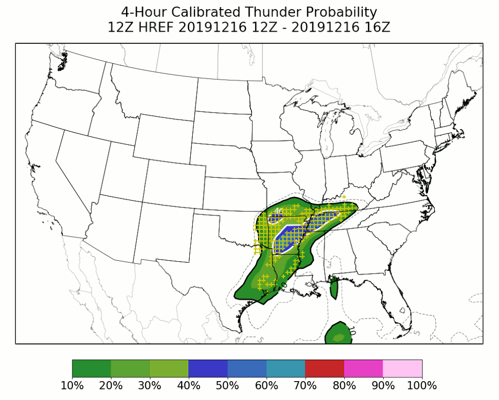
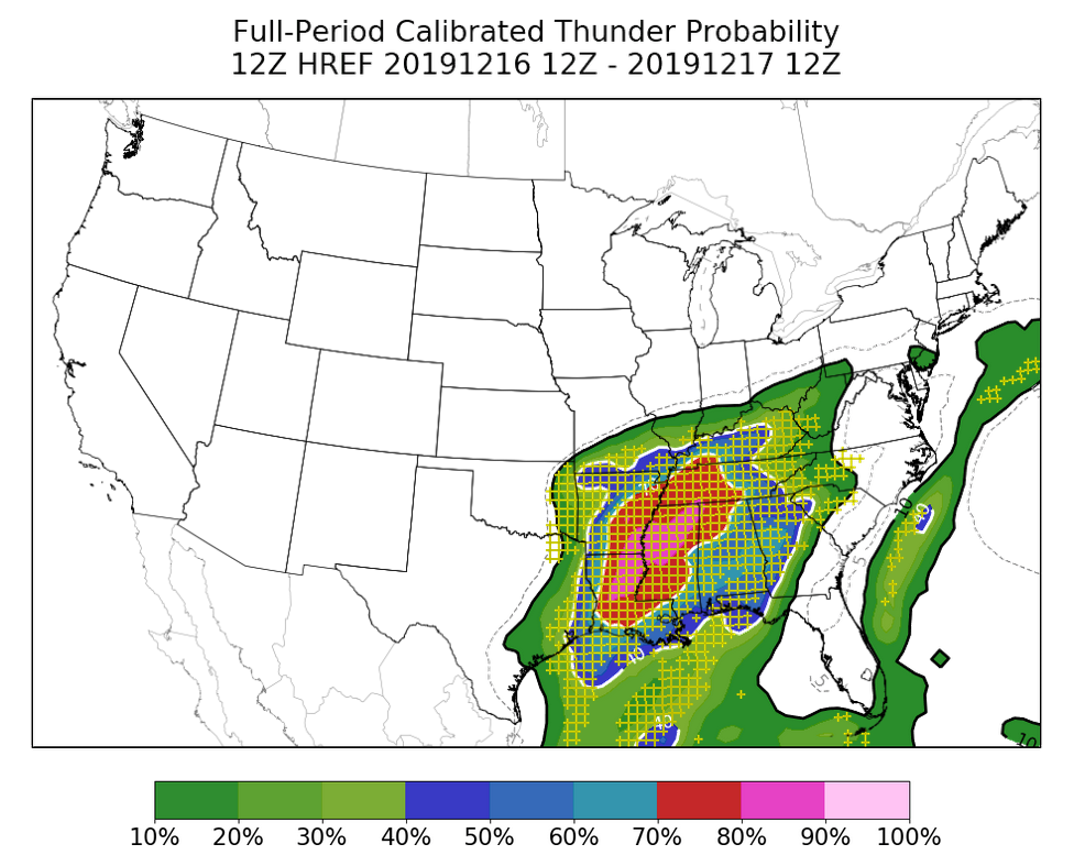
HREF Calibrated Thunder
The High-Resolution Ensemble Forecast (HREF) calibrated thunder guidance is a suite of probabilistic forecast products designed to predict the likelihood of at least one cloud-to-ground (CG) lightning flash within 20 km (12 miles) of a point during a given 1-hour, 4-hour, or 24-hour time interval. This guidance takes advantage of a combination of storm-attribute and environmental fields produced by the convection-allowing HREF to objectively improve upon lightning forecasts generated by the non-convection-allowing Short-Range Ensemble Forecast system (SREF). The HREF Calibrated Thunder guidance has been implemented operationally at the SPC, and probabilistic lightning forecasts are now available to the public on the Storm Prediction Center’s website here. For more detailed information, check out this WAF article.
Watch Probability Guidance
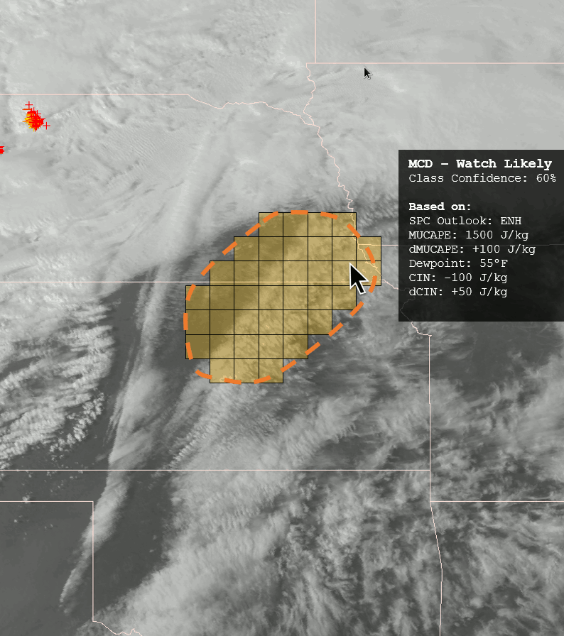
The National Weather Service’s (NWS) Storm Prediction Center (SPC) is responsible for issuing a suite of severe weather forecast products which highlight locations where severe thunderstorms will be possible on time scales of a few hours to a few days. Forecasters at the SPC issue Severe Thunderstorm and Tornado Watches once atmospheric conditions appear favorable for the development of severe weather, with the goal to provide one to two hours of lead time prior to the first severe storm. Additionally, Mesoscale Discussions are typically produced one to three hours prior to the issuance of a watch in order to notify NWS partners of the evolving severe weather threat. As such, SPC forecasters must start planning where, when, and for how long to issue watch products several hours before the first severe storm ever forms. This ongoing research investigates using machine learning techniques to predict where and when a severe weather watch may be needed on a given convective day. Ultimately, the goal of this research is to produce a probabilistic forecast guidance framework to help SPC forecasters better strategize where and when to issue Mesoscale Discussions and Severe Thunderstorm and Tornado Watches before hazardous weather develops.
Rainbow Sherbet
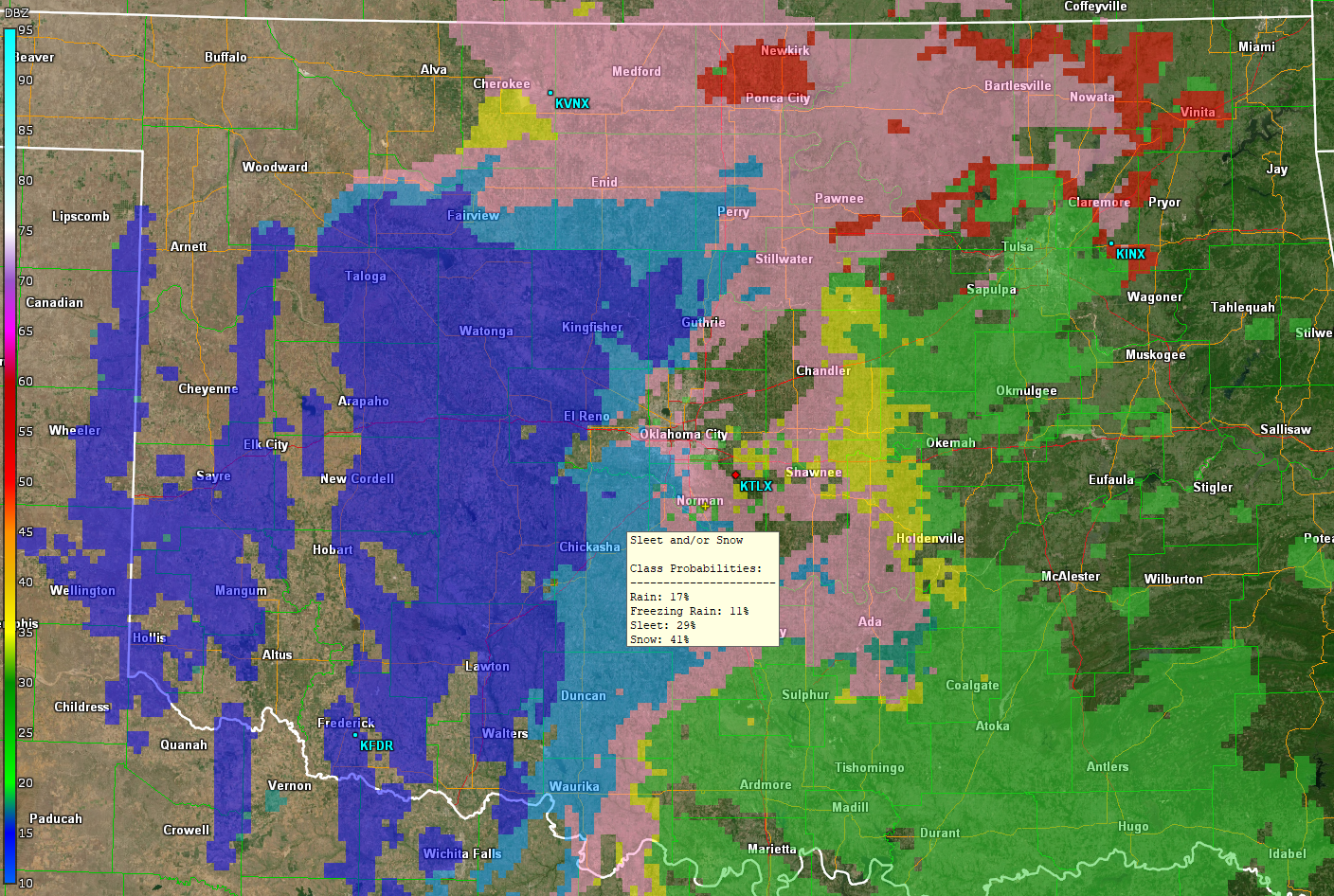
Accurate classification of winter precipitation type has long been a challenge in the meteorological community with important consequences for forecast accuracy, public safety, and socioeconomic impacts. To fill this need, numerous studies in the literature have developed algorithms that utilize static thresholds, bulk statistics, and fuzzy logic to classify precipitation type from observed environmental data, numerical weather models, and radar observations. The overall success of these methods has varied, but the classification of freezing rain (FZRA) and sleet/ice pellets (PL) remains poorly defined. This research utilizes deep learning as a novel, alternative approach to this difficult classification task. In particular, a 1-dimensional convolutional neural network (1D CNN) was trained to identify rain (RA), FZRA, PL, and snow (SN) from rapidly updating, high-resolution numerical weather model analyses and polarimetric radar data. The 1D CNN was found to perform comparable to or better than more traditional methods in the literature. However, FZRA and PL remain a challenge to accurately classify. To better understand the model’s performance, climatologies were created for the environments that the 1D CNN correctly classified and compared to those that were incorrectly classified. Although the 1D CNN accurately learned to identify thermal profiles most commonly associated with each precipitation type, the model remains susceptible to errors in the numerical weather analyses and uncertainty in the reliability of the crowd-sourced observations used for verification.
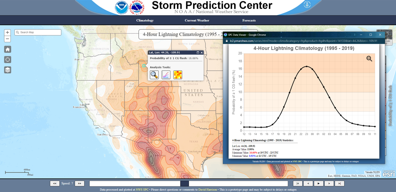
Lightning Climatology
A comprehensive cloud-to-ground (CG) lightning flash climatology has been created to provide an enhanced graphical representation of the spatiotemporal evolution and regional variability of CG lightning flash distribution across the contiguous United States (CONUS). These climatologies were generated for 1-hour, 4-hour, and daily timescales using archived, quality-controlled data from Vaisala’s National Lightning Detection Network (NLDN) between 1995 – 2019. CG lightning flashes were mapped to a 40-km grid, and the frequency of CG flashes over the aforementioned time intervals was computed such that the data represent the probability of at least one CG flash within 20 km (12.5 miles) of a point. A 2-D Gaussian filter was used to spatially smooth the data, and a 7-day running average was implemented to temporally smooth the results. Finally, an interactive web-based visualization tool was developed to more effectively share this climatology with National Weather Service (NWS) forecasters, core partners, and members of the general public. This webpage includes an interactive map interface and grid-point-specific visualizations which provide detailed, localized breakdowns of the data. The lightning climatology webpage is now available to the public on the SPC website.